Day 3
From Headlands Mackinaw City
MI
to Bewabic State Park MI –
Distance traveled: 232 miles
 |
| Early morning lights reflected in the clouds as seen from Headlands Park |
 |
| View to the Mackinac Bridge from the Mackinaw Lighthouse |
Leaving my camping place I headed toward the town of Mackinaw City to stop at the lighthouse for a view to the Mackinac Bridge.
Driving over this amazing bridge is always awe inspiring and today was no exception.
Then of course I just had to stop a few more times at scenic overlooks to see the bridge in the distance.
 |
| View of Lake Michigan from the mouth of the Cut River |
Continuing on my drive I followed hwy 2 westbound along the coast of northern Lake Michigan. I stopped at Cut River Bridge for a hike down to the river and a lovely view of the lake.
 |
| View of the Cut River and the bridge above |
The path follows the Cut River inland and you walk under the bridge.
Epoufettte (a small town on the bay) has a lovely rest stop with a scenic view to the lake.
Further west, I stopped in Naubinway at a "pastie" shop to buy a hot pastie for my lunch.
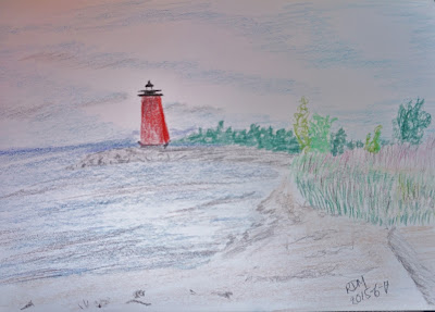
I took my lunch break at the board walk beach were I had a lovely view to the Manistique lighthouse. I sat on the beach enjoying the sea air, the fresh breeze and the sunshine while getting down to some drawing. The lighthouse scene was inspiring me to get creative.
Highway 2 through Rapid River to Gladstone is a very scenic road and you could easily spend an extra day along this section of road stopping for a picnic here, to visit a spring there etc.
 I took a stretch break at the Van Cleve Park in Gladstone where I walked to see this lighthouse and the breathtaking view of the sky above the lake.
At Escanaba Hwy 2 joins with hwy 35 and
turns inland leaving Lake Michigan behind I followed the road to the town of Vulcan where I stopped for the Iron Mountain Mine tour. Can you imagine working deep underground with only the light of a candle?
 |
| Norway Spring |
Continuing west I stopped in Norway at the roadside Norway
Spring where I took a moment to sample the refreshing water and to refill my
empty water bottles at the spring.
 |
| Fumee Falls |
And another stop in Norway was to see the Fumee Falls. There was a lovely trail leading all the way to the top of the falls and from there there was a beautiful view to the meadow and the trees across the road.
 |
| View of Iron Mountain and surrounding hills |
Continuing on Hwy 2 to where it joins Hwy 141 I followed the road to Iron
Mountain. Here I stopped at the “Bat
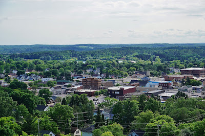
Viewing and Scenic Overlook”. It was a little tricky to find as the instructions I had found were not very clear. After stopping for directions I found the parking lot and went for a really nice hike to the overlook. From here the town and the surrounding hills are spread out in a panoramic display. (If you are looking for this spot stay on Park Ave past East A Street about another 1/4 mile and you will see the sign on the left).
 |
| Bridge over Paint River as seen from the boardwalk |
Another short drive brought me to my final stop of the day in Crystal Falls. Here I stopped in Lincoln Park (on E Crystal Ave) to walk the boardwalk along the Paint River.
Finally a short drive brought me to Bewabic State Park where I set up camp while looking at the sky and expecting more rain. Rain clouds were hanging low all evening. At at midnight for a brief hour the skies turned amazingly clear and the brilliance of the stars left me breathless with wonder and awe. And then the clouds descended once more and the rest of the night was filled with the sound of raindrops on my car roof lulling me to sleep most soundly.
Renate Dundys Marrello
Renate Dundys Marrello
2015 - 06 - 17
see more pictures 


No comments:
Post a Comment