From Ponca State
Park Nebraska
To Beck Camp Grounds
Decatur Nebraska
Total Distance Traveled: 60 miles
Total Distance Traveled: 60 miles
What
a storm last night! The winds were blowing so hard I heard leaves and twigs falling all around. The
rain came driving down and I
had to close even the hatch to prevent water from getting in! Thank goodness for electricity and that I
could have the fan running or it would have been stifling hot!
Then there was the thunder and lightening! As I was wide awake I took to counting the seconds between light flash and sound to estimate how near the lightning strikes were.
The morning dawned with clear blue skies. But there were so many branches down! One nearby camper got hit by a large branch and reported damage. I was lucky and escaped being hit by storm tossed limbs, no branches on my car!
While I allowed the mosquito tent on my car to dry I showered, and ate breakfast and got some writing done. Thoughts were just flowing out of me this morning. It was 11 before I was on the road.
Before leaving Ponca State Park I went to the boat launch to see the Missouri river from the waters edge.
Then there was the thunder and lightening! As I was wide awake I took to counting the seconds between light flash and sound to estimate how near the lightning strikes were.
The morning dawned with clear blue skies. But there were so many branches down! One nearby camper got hit by a large branch and reported damage. I was lucky and escaped being hit by storm tossed limbs, no branches on my car!
While I allowed the mosquito tent on my car to dry I showered, and ate breakfast and got some writing done. Thoughts were just flowing out of me this morning. It was 11 before I was on the road.
 |
| Missouri River seen from Ponca State Park boat launch area |
Before leaving Ponca State Park I went to the boat launch to see the Missouri river from the waters edge.
 |
| View from the Tri State Overlook |
Then I went to the Lewis and Clark Tri-State Overlook. From this vantage point you can see Nebraska, South Dakota and Iowa.
I had another opportunity to drive through the town of Ponca and then continued on Hwy 12 to where it ends at Hwy 20. Then I followed Hwy 20 to Sioux City.
Along this route I spotted a collection of windmills. At first I thought I might be a windmill museum. But the sign posted said L.P Gill Landfill. When I looked it appears to be some kind of methane gas capture program. The variety of windmills did make this spot along the highway stand out with a unique signature.
The rest of the drive into Sioux City was short and pleasant.
I stopped at Scenic Park for some photos of the Missouri River. The view was mostly toward the boat launch area.
While in Sioux City SD I used the local McDonald's for a late lunch and internet break, then I headed to Sam’s for gas and groceries. By now it was 3 pm and I decided to stop at the next camping opportunity along the Missouri River.
I returned to Nebraska on Hwy 77 and then followed highway 75 south, to Dakota City.
 |
| View to the River near Cotton Wood Park |
Here I took a detour to Cotton Wood Park on River Road to see the Missouri River once more.
 |
| Homer Nebraska |
Continuing south on Hwy 75
I passed through Homer
 |
| Winnebago Nebraska |
 |
| View toward Macy from Hwy 75 |
Then I passed through Macy in Omaha Reservation.
 |
| Omaha lands along Hwy 75 |
 |
| View from Blackbird Scenic Overlook |
My next stop was at Blackbird Scenic Overview. Not only was there a stunning view to the east,
there was also a very informative display about the history of the area and river conservation initiatives.
 |
| rolling roads leading into Dacatur |
Stunning views along rolling countryside brought me into Decatur.
 |
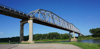
| Missouri River Bridge in Decatur |
Arriving in Decatur I poked around looking for the riverside water front where I discovered this stunning view to the bridge over the river.
From this location I also spotted some campers off to the side. I decided to poke around some more and find the back roads entrance to a tiny 16 site campground where I self-registered for the night. It was by now 4:30 and a nice time to stop and enjoy the evening.
The skies remain clear and it looks like it might be a clear night. I chatted with Mel on the phone and read my book, did some Sudoku and basically had a restful evening.
Renate Dundys Marrello
2015 - 07 - 18
Link to see all of the day's pictures
Link to my Facebook Reflections Page
Route maps for the day
 |
| Route map for 2017 - 07 - 18 |


No comments:
Post a Comment